How the Earth looks from space? Until recently no one could see the earth from space. Although it was known for many years that the earth is round, It was not possible to reach the requires heights to see it. Surprisingly you do not need to go far to see the curve of Earth. Twenty kilometers (14 Miles) upward will be enough, but regular airlines never reach this high, and only few army jet pilots ever reached so high.
In this page I will present many photos of Earth from space:
5 March 2019: Bereshhet spaceship to the moon sent a nice selfie with Australia in the background from about 37600km
Earth from Bereshhet: SpaceIL and IAI
April 2017: (Text from UniverseToday) NASA’s Cassini spacecraft captured the view on April 13, 2017 at 12:41 a.m. CDT. The probe was 870 million miles (1.4 billion km) away from Earth when the image was taken. Look closely to the left of Earth; that pinprick of light is the Moon
Earth and moon from Satrun. Credit: NASA/JPL Caltech
GOES-16 is the first of a new generation satellite which will monitor Earth from GEO (geostationary orbit, like communication satellite). Their height is around 36000km which is high enough to see the entire Earth. The satellite launch was in November 2016 and the first images are from January 2017. Here is a sample of two images.
The first is a selfie on the Earth and moon. The moon looks more or less as it is from Earth but the Earth as a background is unique
MRO mission is orbiting Mars and from time to time needs to calibrate its HiRise camera. The best object to perform this calibration is the moon. The next photo shows Earth and moon together. there are many details and Australia, aAntarcticaand southeast Asia are clearly seen. this is a composite image, but the scale between the Earth and the moon sizes and distance is kept. Photos were taken on Novemeber 20th, 2016.
Earth and moon from MARS. MRO NASA/JPL-CALTECH/UNIV. OF ARIZONA 20/11/2016
LRO mission is flying above the moon mapping it in high resolution. but the scientist decided to turn its camera to Earth and got that results! The photo was taken during October 2015, when the Earth was fully illuminated frrom the moon. You can even see Israel at the top left!
The Earth from the moon. LRO 10/2015. Nasa
Taking this photo was not simple at all. It is made of many seperate photo and required complex maneuvers of the spacecraft and lots of image processing. the result is stunning. Read more about this picture in UniverseToday.
Hayabusa 2 is a Japanese mission to sample an asteroid and return the sample to Earth for further analysis. This will take sometime and after a year in space (The launch was at Dec-2014) the spaceship returns to a flyby around Earth to accelerate toward its target, and not missing the opportunity to take a photo (26-Nov-2015) of the Earth and the moon from 3,000,000 KM.
Earth and moon - Hayabusa2 26-Nov-2015. Jaxa
The latest photo from July 2015 will become common. DSCOVR spaceship is in special orbit and will photograph he entire lit Earth every two hours. One of the first published photos shows earth and the far side of the moon together. Read more about this magnification photo in a dedicated article.
Earth and moon. DSCOVR. NASA
The following photo is from October 2014 taken by the Chinese Chang'e 5 T1 mission. It is an interesting photo showing a large moon and small earth. Obviously. most of the moon surface is from the far side, never seen from Earth,
Earth and moon from Chinese Chang'e 5 TI mission. Credit: Chinese space agency
The next video from NASA MESSENGER spaceship which orbit Mercury showing a complete lunar eclipse from a very unusual point of view. Nothing less than amazing.
An interesting photo is from the surface of Mars. The rover Opportunity took this photo 80 minutes after local sunset on January 31st, 2014. Clean your screen from dust and enlarge the photo to see tiny earth. The zoom-in section shows that the moon also appears in the photo.
Earth from Mars. Source: NASA/JPL/CALTECH
The next photos are from Juno mission to Jupiter. Juno fly by Earth on October 2013 to get just one last gravity assistance in the long way to Jupiter and took some photos of the earth and the moon. NASA made a video from it. Watch and listen.
The following is a mosaic of all photos.
A mosaic of images of the Earth and Moon taken by the incoming Juno spacecraft as it flew past Earth in October 2013. Credit: NASA/JPL
This is nothing less than stunning. You can see how the moon orbit the Earth, the Earth rotation around its axis and how they both gets bigger. Juno's mission is not started and we get so much from it already! There is another photo from Juno below with links to articles about the missions so continue reading.
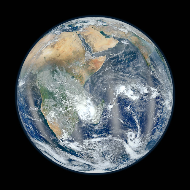
Lets move on to the newest two pictures of earth from space by NASA satellite Suomi NPP which was launched not long ago, and sent back these two picture of earth from space
Space from Earth - Americas. Credit:NASA
This photo can (and shall) be compared to the famous blue marble picture of Apollo 17. Personally I like the old soft photo, as the new photo seems to sharp and digital. Compare for yourself later at this article.
Space from Earth - Africa and Middle east . Credit:NASA
However, the more interesting photos are not from Low Earth Orbit, but from spaceship far far away on wither sides of the earth (Close to the Sun or at the edge of the solar system). Let's start with a recent photo. Juno mission to Jupiter was launched at August 5th 2011, Just 3 weeks after the launch, Juno turned back and photographed Earth and the moon. While it is a simple photo of lots of black and two dots, this photo is very interesting. It is clearly seen that the moon is darker than Earth (Check the article about the moon brightness). Earth is covered with clouds and water which are more reflective than the dark soil of the moon. Also, it is very easy to compare the size of the Earth and the moon. If all you see in the pictures are two dots on a black background, please think again.
Earth and Moon from space. Credit: NASA
One of the most famous pictures of earth from space is from Apollo 8 mission. The astronauts of this mission were the first to saw the far side of the Moon with their own eyes, and they submitted the famous "Earthrise" photo. Before that, and on the way to the moon they photographed the Earth. It was the first time that the whole earth was photographed from space. The astronaut who photographed it was probably Bill (William) Anders, who flight to space only in this mission
First picture of the whole earth - Apollo 8 Credit: NASA
This is the less famous Earthrise photo, just in the moment of rising.
Earth-rise - Apollo 8 Credit: NASA
And this is the more famous photo. Judge for yourself which you like more.
Earthrise - Apollo 8 Credit: NASA
However, Apollo 8 was not the first to photograph Earthrise, an unmanned mission, Luna orbiter, did it in 1966, In black and White poor resolution.
As you probably notice, Earth has phases just like the moon, depending on their angle from the sun. the first photo of the Full earth was captured by the last of Apollo missions, Apollo 17, and was nicknamed "The blue marble"
The full earth from space - The Blue Marble - Apollo 17. Credit: NASA
During 2003, Mars was quite close to Earth (Just 55 Million km). It was a great opportunity to observe Mars, but it was also a chance to photo the Earth from Mars. Mars Global Surveyor took this amazing photo of the Earth and the Moon.
Another very famous photo is the "pale blue dot". It is an amazing photo because it give you proportions about us, the earth and the size of the universe. Our planet is merely one pixel in this photo taken by Voyager 1 from 6.4 Billion km (4 Billion miles).
Earth from Saturn! The earth is a pale blue dot in one of the white stripes (at the right side of the photo). Taken by Voyager 1. Credit: NASA.
Cassini is orbiting Saturn sending amazing pictures day after day. This is a photo showing Earth through the rings of Saturn. Please enlarge the photo and see Earth as a little dot at the left side of the rings.
The earth through Saturn rings. Cassini. Credit: NASA
Next photos are from the Rosetta which is on its way to visit some asteroids in 2014. Its trajectory was designed to save energy and it included an approach to earth, on which the following sequence was taken.
Earth from Rosetta. Credit: ESA
The last photo is from Mercury. Messenger mission took this photo in August 2012 from 183 Million km (115 Million miles) and capture The Earth and the moon as a double star (Binary star) in the sky.
Earth and moon photographed by MESSENGER. Credit: NASA/Johns Hopkins University Applied Physics Laboratory/Carnegie Institution of Washington